A journey into history in the Valley of the Temples – Agrigento, Sicily

A journey into history in the Valley of the Temples – Agrigento, Sicily

We arrived in Acragantas (its Greek name), Agrigento (a super musical name!), crossing the island from north (Palermo) to south, having the opportunity to get to know the inland with its endless fields of grain. Countless bales of straw scattered over vast expanses. A very artistic sight! Our visit had the sole purpose of touring the archaeological site, the “Archaeological Park of the Valley of the Temples”. We left the modern city for another visit!

So let’s meet Acragantas, in southern Sicily, one of the most brilliant cities of Magna Grecia. It was founded in 582 BC by colonists from Gela. The “most beautiful city of mortals”, as the poet Pindar called it, was a rich city with great power, home to artists, philosophers and important men of history. So, the number one reason of your visit is the “Valley of the Temples” (La Valle dei Templi). You will be impressed! Take note on the the temperatures and if it’s too hot, make sure you are properly equipped! You will need considerable time to explore the vast area amidst the olive and almond trees, between the sea and the modern city of Agrigento. Here people really struggled to save the large number of surviving temples. You will see memorial plaques with the names of those who fought for it. Since 1997 it has been a UNESCO World Heritage Site.

The 1,300-hectare archaeological site includes 10 Doric temples, 3 sanctuaries, a necropolis, hydraulic works, fortifications …… and many more. What do we suggest you do?

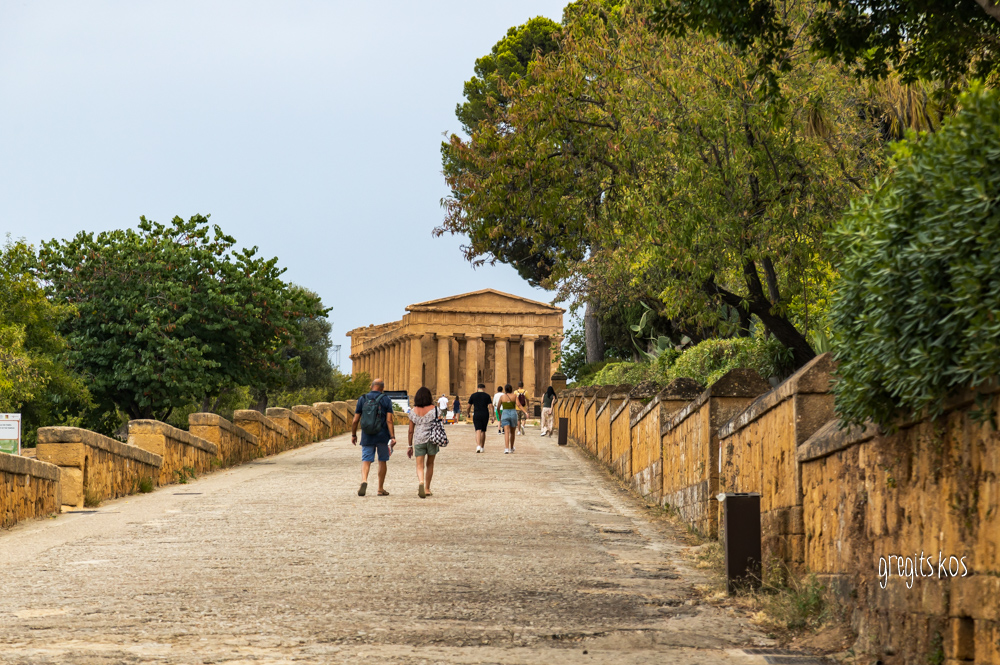
Start from the top of the archaeological site and go down the hill. First, stop at the Temple of Hera Lacinia (Tempio di Hera Lacinia), standing at an impressive location, at the top of the hill, with 24 surviving columns and obvious traces of the fire of 406 BC, when it was destroyed by the Carthaginians. Further down, with the ruins of the Greek Walls (Mura Greche) on your left, walk along the Via Sacra to the famous Temple of Concordia (Tempio della Concordia), one of the best preserved in the world. It was adopted as the logo for the UNESCO emblem. Its peristyle consists of 34 columns, on a base with 4 steps instead of the 3 that the temples in Greece had. Continue in front of the Villa Aurea to the Temple of Hercules (Tempio di Ercole), the oldest of all (6th century BC) with 8 of the 38!!! original columns standing today. To the east of the temple you can see the ruins of a large altar. In Sicily, Hercules was worshipped as a god and not as a demigod!

Enter the area of the Temple of Olympian Zeus (Tempio di Zeus Olimpico) (5th century). It was the largest in the entire West (113x56m). On its façade, instead of columns, stood Telamons, naked giants 7.60 meters high, who like Atlases held the roof on their shoulders. One of them in life size was in the space in front of us standing upright so that we could get a sense of its enormous size.

In a large area below is the complex of sanctuaries of the Chthonian Deities (Demeter and Persephone) and within it the Temple of the Dioscuri (Tempio dei Dioscuri) with its 4 remaining columns (it has become a symbol of the city).

You need two hours for this tour. However, there’s much more to see at the archaeological park on the side below the hill with the temples. It is the ancient city of Akragantas, with the Agora and the Vouleuterion, the Regional Archaeological Museum, the Necropolis and temples outside the walls, but also the Garden of Kolymbetra.

Organize yourself according to the time you have to spend and enjoy your experience on an immersive journey through history!

¬ There are 2 entrances. Porta V (east) and Porta Giunone (west) with more parking spaces. We started from there! In between them there a 2 km. distance.

¬ The best time is early in the morning. Fewer people, less heat. Minimal shade in the area!

¬ The ticket costs €17 (general admission). We got in for free with a Greek free-entry teacher ID!

¬ See here a useful digital map of the area as well as updated information about tickets and opening hours of the area:

https://www.lavalledeitempli.it/en/itineraries/temples-valley/archaeological-itinerary/

¬ Valley of the Temples Archaeological and Landscape Park itinerary

https://www.visitsicily.info/en/itinerario/landscape-and-archaeological-park-of-the-valley-of-the-temples/


https://www.orangesmile.com/travelguide/agrigento/high-resolution-maps.htm

A day in Palermo!

A day in Palermo!

Porta NuovaIn the largest port of Sicily, you will feel at first sight the rich history, the authenticity of the place with the impressive architectural buildings that combine unique architectural motifs of different eras! Quite a few conquerors passed through this land!

Start the tour by walking through Porta Nuova, a 15th-century gate with impressive sculptures, a monument to the victory against the Tunisians. It is located next to the Palace of the Normans (Palazzo dei Normanni) which you will see later, making a stop in the beautiful park in front of it. An Arab building of the 9th century, characteristic of the cultural diversity of Sicily that was expanded and decorated by the Normans in the later years. Byzantines and Spaniards also overran the area. Visit the Capella Palatina chapel for the unique Byzantine mosaics.


Palace of the Normans

Head to the Palermo Cathedral (Cattedrale di Palermo), another example of a mix of architectural styles. What about Gothic, Norman, Byzantine and Arabic influences? You will discover them in this magnificent building outside and inside. Take some time to explore all its corners, see the unique mosaics, wood carvings, royal tombs and the underground crypt with the sarcophagi. Don’t miss the heliometer on the floor! Before leaving, “climb” to the roof for a panoramic view of Palermo!

Palermo Cathedral

Next, make your way to Quattro Canti (Piazza Vigliena), the landmark square in the heart of Palermo’s historic center. An excellent example of Baroque architecture, the “Four Corners” as its name suggests, are perfectly symmetrical, defining the corners of four ancient districts at the intersection of two main streets. The rich symbolism in its design makes it unique. Each of the four facades is divided into four levels, each with its own representation of the cultural and religious life of Palermo. At each base, you can see one of the four seasons symbolizing the cyclical nature of life, as well as a figure for each element of nature (earth, water, fire and air). On the middle tier, sit each of the four Spanish kings who ruled Palermo during the 17th century and on the upper tier the 4 female patron saints of the four historic districts of Palermo. Above them all, the royal coats of arms! We were staring up and around for a while… speechless!

the "Four Corners"

Next stop at the Teatro Massimo square, one of the largest opera houses in Europe. A meeting point for many, the impressive building with its imposing size is known for the high-level performances it hosts. If you’re interested, you can also visit its interior or possibly watch a performance. Horse carriages are waiting in the square for a stroll around the city in a different style.

Teatro Massimo square, one of the largest opera houses in Europe

That’s all fine but you will also find Sicilian cuisine at its best in Palermo. Great choices of street food like “arancini” and “cannoli” and many more as well as traditional dishes like “pasta alla norma” with tomato sauce, eggplant, basil and ricotta or an authentic “caponata”. The pasta here (be careful not to ask for macaroni as we Greeks refer to all kinds of pasta – it will be remarked!) is often handmade and in any case cooked al dente). Pizza will be super wherever you eat it, as well as seafood dishes.

There is still much more to see and do depending on your interests. Do some exploring for the joy of being a traveler!

TIPS

  • Many restaurants are usually closed for siesta (usually 3:00 PM-6:00 PM)! This is an issue. And some attractions too! So, see that you plan your schedule and check the hours!
  • Most locals don’t speak English. However, you will surely find a way to communicate. Everyone is very willing and helpful!
  • All the products of the land (vegetables, citrus fruits, etc.) are extra tasty here since they are grown in the fertile volcanic soils of the island.
Alberobello – the city of trulli

Alberobello – the city of trulli

AlberobelloIn the city of trulli, Alberobello, a fairytale open-air museum and a UNESCO World Heritage Site since 1996, you will fill your photographic memory! Approximately 1,500 round houses with conical roofs, in gray and white, compose a unique setting. The history making your tour even more interesting. They are the Trulli, stone dwellings, remarkable examples of dry-stone construction, unique in the Puglia region!

It is said that the inhabitants of the region, in the mid-15th century, in order to avoid a harsh law of the kingdom of Naples that taxed constructions with binder material, chose to build these houses like beehives, with limestone slabs and without any connection between them, while on the roofs they placed thinner slabs in circular rings. This way they could easily dismantle them when the tax collectors came and reassemble them when they left! 

Alberobello – the city of trulli

On the roofs you will see painted symbols in white that bring luck or protect against the evil eye. In the shops you will buy local products and souvenirs, you will taste the focaccia delicacies at the square, in the narrow streets you will see Trullo Siamese and the Trullo Sovrano (a rare example of a two-storey building) which operates as a museum and at the Vista Panoramica de Trulli point (next to the church of Santa Lucia, as you reach the square on the upper right) you will admire the panoramic view. Stroll around seeking for the perfect photo! Quite challenging!!!

Alberobello trulli

  • At the base of each roof there was a specific stone that if you pulled it out, the house would be dismantled! They say that within half an hour the whole village could be demolished.
  • Alberobello means “beautiful tree”. The area was overgrown with oak trees and generally very forested.
  • You can feel the unique experience of staying in a dome, since most domes are used as tourist accommodations and shops rather than for residences.
  • We ate very delicious focaccia in various versions at Focacceria La Lira (https://www.instagram.com/lalirafocacceria/ ) at the square!
Alberobello trulli painted symbols in white that bring luck or protect against the evil eye

All information about events and other updated information here: https://www.alberobello.com/en

Ghent – In a fairy tale scenery

Ghent – In a fairy tale scenery

Discover the most compact historical center on foot or by bike, relaxed and calm in medieval Ghent, with the largest low traffic pedestrian zone in Europe. You can always take a tram of course! A pedestrian friendly city, supporting sustainable, environmentally friendly activities with the smallest possible ecological footprint.

Saint Michael’s Bridge

By doing so, cars are not allowed to enter in the historic center unless they are electric or at least hybrid vehicles. Ours was a hybrid and we parked it at Parking Ramen as close as possible to the center, two blocks from Saint Michael’s Bridge.

Graslei and Korenlei quaysWell, start on foot! On the right before the bridge, you see Saint Michael’s Church and as soon as you step foot on the homonymous bridge you have a 360-degree field of view in a magical setting. From this point you can see all 3 towers of the city in a row, the river Lys and the Graslei and Korenlei quays along the canal with many restaurants and small shops, people strolling or sitting and enjoying the wonderful view of the historic buildings. And of course, taking pictures of every corner of the impressive houses on the banks! Here you can book for a the water route with various types of boats if you choose to see the highlights of Ghent by boat on a guided tour.

Continue straight. On your left there’s a magnificent building, The Post. Once the city’s historic post office, today hosts a shopping center and a luxury hotel on the upper floors. We are talking about masterpiece facades, decorated with about 100 statues and coats of arms along with the 51-meter tower with the unobstructed view.

In front of you is the Church of St. Nicholas (Sint-Niklaaskerk) with its tall bell tower – a trademark of the city on Korenmarkt Square, opposite The Post. Built of Tournai blue stone, it is considered one of the most beautiful examples of the Scheldt Gothic style with unique works of art (paintings, stained glass…) inside. Admission is free, open until 4:00 PM. Proceed with the church on your left, take a rest maybe at the little park behind it.

Stadshal

Now you tell me where to look first! Straight ahead is the Belfry of Ghent (Belfry), on the left is the futuristic Stadshal or Market Hall and if you look further into the square is the City Hall (Ghent City Hall). You are at Sint-Baafplein Square. The Stadshal is a clear example of a peculiar combination of modern architecture in a medieval environment that caused, no need to say, reactions. We loved it. It proves that the city is alive! Climb up the Belfry, with the 1913 manual mechanism and the dragon guarding the city, for a panoramic view of the city. (There is also an elevator from the 1st floor). During peak periods, register and secure your entry HERE https://tickets1belfort.gent.be/Exhibitions/Register

Just behind Belfry is the Cathedral of St. Bavo (Sint Baafskathedraal) with its 40 bells. It is considered a world-famous masterpiece of Gothic architecture. There you will see: the Ghent Altarpiece (or: “The Pilgrimage of the Secret Lamb”), a multi-faceted work by the Hubert and Jan van Eyck brothers (15th century). Take your time to observe the 12 separate panels and the story they tell! Explore the impressive interior, the stained glass windows and sculptures. For the complete experience you will need a ticket. See here: https://www.sintbaafskathedraal.be/en/buy-tickets/  There are also stairs here for the brave ones (444 steps for a view). Next to it is the very beautiful building of the Royal Dutch Theatre. Walk along and take the road behind the City Hall (Hoogpoost str.). As you head back towards the bridges, take a look at the alley with the graffiti (Graffiti Street). Cool graffiti in a narrow alley. Every inch an explosion of colors. All its walls are free for artistic expression!

Ghent graffity

You have walked in a circle around the centre and you find yourself on the Grasbrug bridge. As soon as you cross the river, turn right. Stop for coffee/beer/snack at Et Alors café just opposite the Design Museum. And after that off to Gravensteen Castle, a symbol of the power of the Flemish comets, the only one with a moat around it. Visiting the castle takes time. Inside, each room tells a different story, from the ancient weapon displays to the dark, dramatic dungeon. The view from the top is amazing. If you don’t have time, take a walk around it. There are nice shops area as well. Try the local delicacy, cuberdon, (conical, purple sweets) in one of them.

Gravensteen Castle

Sirrako – Kalarrites two neighbors in North Tzoumerka

Sirrako – Kalarrites two neighbors in North Tzoumerka

SirrakoAugust in the high Tzoumerka mountains means greenery, waters and bridges, a stone scenery everywhere around and a rare peace from the moment you take the road into the mountains. The snake shaped uphill road on the slopes of Mount Lakmos, leads us to Sirrako. Hooked on the slope and merged with the landscape. A stop for panoramic photos on the ring road that leads to the upper entrance of the village is a must. Cars can’t enter the village, so park your vehicle at the open space before the first houses or in the area before the stone gate. There is also the central entrance at the low point of the village if you prefer! And here starts the walking on the cobblestone alleys! All with a considerable incline, so mind the shoes you wear! Along the way, I realized how essential a stave is and why all the residents were using one!

In the central square, laid out in levels, young and old gather. Some sit on the terraces under the dome of the impressive fountain “Gura” (“mouth” in Vlach), others in the forecourt of the church of Agios Nikolaos (gold-woven Russian epitaph and excellent wood-carved iconostasis). Everyone speaks Vlach! I’m eavesdropping to catch some words, but… in vain! The younger ones meet on the lower level of the square where there are also 2 tavernas. Taste the traditional dishes!

Casa caldaOur guest house (Casa calda) is dreamy on the highest point of the settlement, with its courtyard, its stone arches, its view! Carved stone on the walls and slate roofs of all the houses in the village rebuilt according to the local traditional architecture.

The cobblestones climb the slope, pass through all the doors creating a picturesque setting. Every corner is a frame! I spontaneously think how much effort was needed to keep them so well preserved since the means are lack due to the physiology of the place. We take the downhill alley towards the center of the settlement. Apart from the main square there is the statue square. We walk through all the narrow streets; we enter the house of K. Krystallis (today a museum-library). An enthusiastic guide welcomes us and speaks passionately about the history of the place and all the culture and daily life of the area. Stop at the Folklore Museum of Avdikos and the old school (a guesthouse nowadays) which stands out in its place due to its size. Enjoy coffee or food in its yard (we went late in the afternoon)
Although the permanent residents are around 50, the village comes alive during summer, as we were told. A big festival is held here on August 15th.

monastery of KipinaNext outing the Chrousia gorge which was the Greek-Turkish border from 1881 to 1912. It separates the neighbor settlements of Kalarrites and Sirrako. You can see the neighbor across the street, but you have to run the miles to reach it. 3 km on foot, 25 by car and a 45′ ride. If you drive though, you have a bonus! You have a chance to visit the monastery of Kipina (Assumption of the Virgin Mary) on the way to Kalarrites. See beforehand that it’s open to visitors because it’s not to be missed! Adhered to the wild rock overlooking the gorge of the Kalarritikos river, it is impressive inside and out. Inside the cave, in the church, 17th century hagiographies are preserved until today. What strength did people have to build what our eyes see! (TIP: If it’s winter, ask for the key in the village, in Kipina.)

Kalarritikos stream – KouisaAfter a 4′ drive, further on you meet the point where you can enter the gorge, stop at Kouisas Bridge. Do so! At a short distance (10′ walk) there is an old water mill that functions as a refreshment stand. Cool your feet in the water of the Kalarritikos stream (if you can stand the cold temperature!). And then head uphill again at 1200m. for Kalarrites. Cars are not allowed here as well.

It was once a village of silversmiths with their workshops manufacturing famous ecclesiastical silverware and jewelry. It is said Bulgari started his business here! Samples can be seen at the Museum of Silversmithing (old school building). But they also excelled with wool, capes and woven fabrics. All this from 1750 to 1821. Agios Nikolaos church stands (1480) high up the hill and there are stone fonts with names all around like “Nessis” (at the square), “Goura”, “Fitros” and “Parashis” with the vaulted dome. Kalarrites the squareWalk through the narrow streets with the old mansions of the rich merchants who once lived here and at the square enter the house-museum of A. Golfinopoulou. The family still lives in the 1872 mansion and guides visitors to old times through the wealth of exhibits.

Off to “Akanthos” tavern directly across the street, a little higher up from the square. Napoleon and his wife prepare special local dishes in the oldest department store in the area. It functions as a grocery store-cafe-tavern-shoe shop all at the same time being almost 200 years old! It’s a time travel, you’ll see!

AkanthosNow, if you stay longer, spend a day at the villages on the opposite slope. Pramada, Agnanda, Tsopela and Melissourgoi. You can easily reach the bridge of Plaka as well. Estimate the distance at 2-3 minutes’ drive per a kilometer.

Set off for Pramada, drive past them and head for Anemotrypa cave. Unfortunately, we didn’t manage to enter for a tour. But you check it out and visit! They say it’s totally worth it! Entrance fee costs 3 euros (tel. 26590 61516, 6958054441).

Plaka bridge Plaka bridge

Plaka bridge was our reward! Built in 1866, it is the largest single-arched bridge in the Balkans, with a span of 40 meters, a height of 19 meters and an opening at the top of 3.2 meters. It was reconstructed in 2019. See that you have to turn right before entering the settlement. Otherwise, the road will take you to the other side of the river and you will have to walk a long way on the path to the end of the bridge. However, you will be compensated by the panoramic view! Arachthos is full in clay and the water is grey when it rains. Go in for a natural spa! Many choose to go down the river in boats. And a nice refreshment bar operates in the building of the old customs office next to the highest bridge in the Balkans.

PramadaWhen lunch is at question choose Pramada for food with a view, in Boutzas tavern. Their spits are turning mercilessly! If it’s Sunday and you fancy a table by the window, you need to be provident and book one on time. Note that I have never seen a village with so many visual arts on every wall, corner and square. And everything taken care of. Well done!

“Horizons of Tzoumerka” resort, next to Tsopelas settlement was our next visit for a coffee. Fill your eyes with amazing nature views. As if entering some poster… you feel like running on the grass with the peaks of Tzoumerka in the background. Sweets and coffees arrive on the terrace! Enjoy!!!

There are more to see and do in the area depending the time and the type of tripper you are. The place can easily meet all nature lovers’ needs!


Orizontes resort

GOOGLE MAP